The Research Group is Moving!
During winter term 2021/22, we move to University of Bamberg. From Oct. 15, 2021, Fabian Beck holds a full professor position on Information Visualization.
New webpage of the research group: https://www.uni-bamberg.de/vis
News
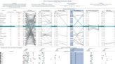
Mon, 04. Oct. 2021 Krause, Cedric
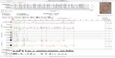
When AIs disagree
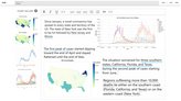
Tue, 21. Sep. 2021 Latif, Shahid
Interactions that Connect Words and Numbers
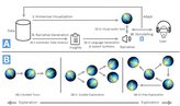
Thu, 11. Feb. 2021 Tarner, Hagen
Talking Realities
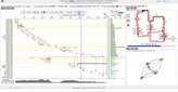
Wed, 16. Dec. 2020 Agarwal, Shivam
Community Support Awarded: Visualization of Intelligent Train Scheduling
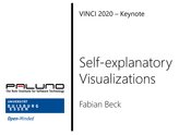
Wed, 09. Dec. 2020 Beck, Fabian
Self-explanatory Visualizations
Thu, 22. Oct. 2020 Agarwal, Shivam
Don’t be Afraid of Rejection

Mon, 19. Oct. 2020 Beck, Fabian
Presenting our Research in Videos
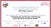
Tue, 06. Oct. 2020 Agarwal, Shivam
Visualization of Changing Categories Receives VMV 2020 Best Paper Award
Tue, 30. Jun. 2020 Hagen Tarner
Participation in International Seminar on Software Evolution
Wed, 17. Jun. 2020 Beck, Fabian
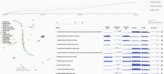
Complex Temporal Bahavior Unrolled

Fri, 10. Jan. 2020 Beck, Fabian
Learning from Network Comparison

Thu, 09. Jan. 2020 Agarwal, Shivam
Awarded: Visualization Support for Artificial Intelligence Development
Currently showing 1 to 12 out of 33